


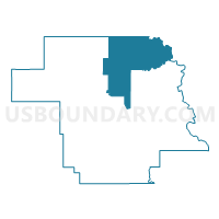
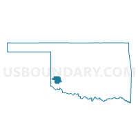
Voting District 301, Greer County, Oklahoma
About
Outline

Summary
| Unique Area Identifier | 654077 |
| Name | Voting District 301 |
| County | Greer County |
| State | Oklahoma |
| Area (square miles) | 86.34 |
| Land Area (square miles) | 86.27 |
| Water Area (square miles) | 0.07 |
| % of Land Area | 99.92 |
| % of Water Area | 0.08 |
| Latitude of the Internal Point | 35.05259100 |
| Longtitude of the Internal Point | -99.49156060 |
Maps

Graphs
Select a template below for downloading or customizing gragh for Voting District 301, Greer County, Oklahoma


Neighbors
Neighoring Voting District (by Name) Neighboring Voting District on the Map
- Voting District 105, Greer County, OK
- Voting District 111, Greer County, OK
- Voting District 203, Greer County, OK
- Voting District 242, Beckham County, OK
- Voting District 302, Greer County, OK
- Voting District 8, Kiowa County, OK
Top 10 Neighboring County Subdivision (by Population) Neighboring County Subdivision on the Map
- Sayre CCD, Beckham County, OK (5,321)
- Mangum CCD, Greer County, OK (3,613)
- Granite CCD, Greer County, OK (2,365)
- Lone Wolf CCD, Kiowa County, OK (969)
- Carter CCD, Beckham County, OK (672)
- Northwest Greer CCD, Greer County, OK (261)
Top 10 Neighboring Place (by Population) Neighboring Place on the Map
Top 10 Neighboring Unified School District (by Population) Neighboring Unified School District on the Map
- Sayre Public Schools, OK (5,520)
- Mangum Public Schools, OK (3,583)
- Merritt Public Schools, OK (3,360)
- Granite Public Schools, OK (2,556)
- Sentinel Public Schools, OK (1,800)
- Lone Wolf Public Schools, OK (830)
Top 10 Neighboring State Legislative District Lower Chamber (by Population) Neighboring State Legislative District Lower Chamber on the Map
- State House District 60, OK (36,383)
- State House District 55, OK (35,481)
- State House District 52, OK (32,109)
Top 10 Neighboring State Legislative District Upper Chamber (by Population) Neighboring State Legislative District Upper Chamber on the Map
Top 10 Neighboring 111th Congressional District (by Population) Neighboring 111th Congressional District on the Map
Top 10 Neighboring Census Tract (by Population) Neighboring Census Tract on the Map
- Census Tract 9668, Beckham County, OK (5,993)
- Census Tract 9642, Kiowa County, OK (3,668)
- Census Tract 9672, Greer County, OK (3,613)
- Census Tract 9671, Greer County, OK (2,626)
Top 10 Neighboring 5-Digit ZIP Code Tabulation Area (by Population) Neighboring 5-Digit ZIP Code Tabulation Area on the Map
- 73662, OK (6,093)
- 73554, OK (3,614)
- 73547, OK (2,319)
- 73655, OK (864)
- 73627, OK (628)
- 73673, OK (319)